 - ISLAND VENTOTENE - OFFERS - HOLIDAYS
Login


Excursions

Historical Itinerary-the Bourbon Period
The building of the church began on the 13th of March 1769 and was dedicated to Saint Candida on the 22nd of September 1774, overseen by the Capuchins until 1792 when they left the church to laymen. The complex includes the church itself in the center, in the neoclassical style. On it's left there was a convent which was named the Cenobio od Ospizion. Within the church it is worth noting a painting depicting the Madonna, perhaps by the painter Sebastiano Conca. It is worth noting also a beautiful wooden statue of the Saint that was carried during a procession in celebration of Saint Candida.
Historical Itinerary - the Prison

Carpi was put in charge of the building of the prison. He designed the prison following a theory that had been outlined in the previous twenty years by Jeremy Bentham. Bentham sustained that by building an adequate architectural structure, it was possible to have ‘complete control over the prisoners’ minds’. Thus Carpi based his design on the structure already used in Ventotene, which was designed as a horse shoe formed by three floors of archways and loggias facing inwards so that the prisoners were constantly aware of the power the prison officers had over them. It goes without saying that this had a hugely negative psychological effect on the prisoners, aggravated by the fact that there were no windows overlooking the sea!
The horse shoe space of three floors was divided into ninety-nine prison cells measuring 16 hands by 17 hands, each with a view on the internal courtyard and each preceded by an archway. The cells were organized in a way that prisoners who were well behaved got the top floor, whereas those who were rowdy and unsettled got the ground floor. The closed circular area separates the cells from the ground floor, leaving a fortified opening serving as a passageway for the prisoners. A hexagonal shrine adorned with an altar was placed in the middle so that prisoners with life sentences could view it at all times. Within the enclosure there still are cisterns, lights and a railing that were used as a repository. Further on there is a round building which had a decent hospital and lodges for the Commander, the chaplains, health officials and prison officers.
The penitentiary was inaugurated around the 16th of September 1795 when it received two hundred prisoners. Two years later building was completed and the number of prisoners rose to six hundred, allocated to ninety nine cells. On the lower levels the cells didn’t have any windows. In 1853 two square rooms at the entrance named ‘orecchioni’ where completed and used as laboratories. Around the middle of the 19th century a terrace communicating with the outward building was completed. It was divided by two corridors leading to the hexagonal chapel and the cisterns. Later on two small towers built on cobblestones were placed North and South of the cells overlooking all three floors. Another change was made when the cells were divided by transforming their small windows with view on the balcony into doors. At the same time a a circular annex was built slightly lower than the first floor to the rear of the prison. These cells didn’t have any windows so whatever air or light they had came from the corridor. One can only imagine the conditions the prisoners, that at one point amounted to nine hundred, found themselves in.
In 1799 the first political prisoners were sent to the Santo Stefano penitentiary, closely followed by Neapolitan revolutionaries, thus changing the make up of the prisoners who had initially been common criminals. At this time, the illuminist and humanitarian philosophy came under attack, unveiling the brutal reality of the prison where physical punishment and torture was practiced regularly, occurring under everyone’s’ eyes with frequent death being the norm. The prison soon became the place where certain prisoners were sent to ‘disappear’, a practice that did not change with the advent of the Regno d’Italia. In 1900 Gaetano Bresci, the famous anarchist who on the 29th of July had killed King Umberto I, was detained in the prison. A year later he was found dead in his cell, hung by the guards, his body most probably thrown into the sea. In time the use of physical torture diminished but during the Fascist period in particular, the prison was used to detain controversial figures such as Umberto Terracini, Sandro Pertini, Mauro Scoccimarro and Rocco Pugliese, who ‘conveniently’ killed himself in his cell. After the Second World War the penitentiary was used once again to detain common criminals.
Santo Stefano prison was officially closed on the 2nd of February 1965.
Historical Itinerary - Roman Imperial Port

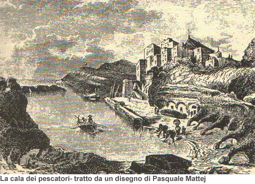
The first thing you notice in the Roman port is a line of archways on the right, carved into the rock, which also serve as storage sheds. On the left the port is protected by a boundary that is also made of tuff stone. The whole area was built by transporting around 60,000 cubic meters of original tufa! One can see next to the port's entrance, facing the Levant, a cavity with an opening above that contained the chains used to close the port when the sea was dangerously rough. Along the waterfront is the Pozzillo, built as a vent for backwash and is where boats are towed. Between the entrance to the port, the Pescheira and the Pozzillo, there are three bollards carved into the tufa which were used by the Romans and are used today to moor the boats. Just before the Pozzillo there is a beautiful flight of stairs, built during the urbanization period of the Bourbons, that lead to the Church square and the center of Ventotene.
Historical Itinerary - the Roman Villa of Giulia

The villa, named Julia after the daughter of Emperor Augustus who was sent there in exile, was most probably built during the beginning of the Emperors’ reign. Situated on the northernmost tip of Ventotene, it is more than 300 meters long and around 100 meters wide. Once the Romans began to abandon the island (it was owned by the emperor), the villa was systematically plundered, the spoils providing construction materials for chance inhabitants or items for private museums, as was the case with the sack of Sir William Hamilton in the 18th century. The best way to reach the villa is from it’s southern point by a ramp that connects Cala Rossano to the island’s cemetery. The distribution of each area of the villa matches that of the land which naturally individuates three ‘zones’.
The southern zone covers the entire area between the cemetery and Cala Rossano which was not as deep as it is now and served as a landing place for boats. This zone was directly connected to the villas’ ‘services’ such as the kitchen and cisterns. At the beginning of the path that runs along the bay there are some caves that were connected to an ancient cistern used to collect water from the Roman aqueduct that brought water from the large Prison cistern. The whole area is generally called the Domus. Part of the Domus is a great exedra carved into a small valley that connects it to the sequent zone.
The second zone can be identified as a xystus that is a green area used for horse riding, which can be discerned by two large open areas placed side by side where on one side there was a long corridor for horse riding and walking and the other side was a garden.
The third zone is situated in the area leading up to Punta Eolo and was the principle residence with a sea view along a North-South axis. One can see from the skeletal brickwork that the residence was equipped with sumptuous nymphea and baths overlooking the sea, stairs and terraces connecting them all.
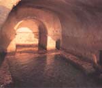
Historical Itinerary - Ancient Roman Cisterns
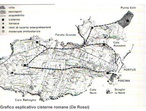
The first cistern, named ‘of the prisoners’ is situated about a kilometer from the Castle square, to the right of via Ulivi. It’s name originates from the period when it ceased being used for the collection of water and was used instead as lodgings for the convicts who built Ventotene under the Bourbons. It is an enormous reservoir carved into tuff stone around 10 meters below an area of open countryside. It would collect rainwater and is made up of two communicating galleries that would sometimes be covered and used for water conservation.
The galleries widen out into three corridors on the side. In the eastern part of the open basin there were conduits for water transport (the passageways made of lead ). Once it stopped being used for water collecting, the cistern became a shelter for men and animals, as one can see from various graffiti forms and paintings from many eras on It’s walls. A blow-hole was built at the level of the countryside to compensate for the misuse of the prison, providing much needed air for It’s prisoners.
The second cistern is located about 400 meters from the first, to the left of via Ulivi and is referred to as ‘grotta Iacono’, which was the name of a family sent by the Bourbons in 1772 to settle in Ventotene. The cistern is also referred to as the cistern of ‘Villa Stefania’, coming from the name of the wife of one of the Iaconos in the 18th century. Access to the cistern is via a stairway covered by an archway located at it’s most south-western point.
Historical Itinerary - The Roman "Peschiera"
The Peschiera Romana is best visited from the water and, if possible, with a snorkel or diving gear so if you are a scuba diver do not hesitate to use your last reserves of air to take a look. There are three entrance ways. Considering that since the Roman Empire the sea level has gone up by around a meter, nowadays much of the Peschiera can be admired underwater.
Nature Itinerary - Semaforo, Parata Grande, Moggio di Terra, Punta dell'Arco

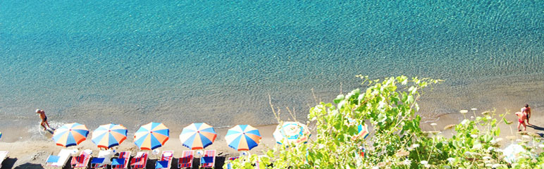
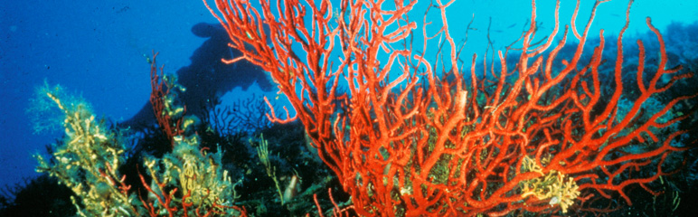
Departure from the Centro polisportivo in Cameroni, follow the coast with lined with fields that cultivate lentils and you will arrive to a strip of sand backed by a wall that is Parata Grande. From it’s elevated position you can observe typical sea birds such as sea gulls, berets and wood pigeons. A cement staircase leads to a small pebble beach littered with posidonia and sea weed. In the sea wells or just under the waters’ surface lie coelenterata (jelly fish, coral, gorgonacea, sea anemone), mollusks ( murices, chitons, patella, sea hares, litodomi) shellfish (crabs, hermit crabs, prawns) and echinoderm (star fish, ofione, sea urchins, sea cucumbers). Going back up there are many plants accompanying the stairway such as wild wallflowers, sea lavender, samphire, giant fennel, agaves and borage. If you continue along the path of Parata Grande you will get to Via Ulivi at which point you need to go in the direction leading away from the built-up area. At about 800 meters, visible from a ridge, is Semaforo, an old antiaircraft post from the Second World War, recently transformed into the “Ornithological Museum”. The Semaforo is a splendid observation point for viewing the entire island and for watching birds such as sea gulls and small falcons that soar above. Like all the other Pontine islands, Ventotene and Santo Stefano are very important for migrating birds. Indeed, these two island are situated on the European-African route for migratory birds and are thus present an ideal spot for rest and replenishment. Many years of research have documented 194 species of birds on the various Pontine islands seven of which are non-migratory.
Regaining the itinerary from where the path runs along a cliff called Moggio di Terra, is it not unusual to see, particularly in May and June, the joyous jumps and pirouettes of a small group of bottlenose dolphins, that inhabit the island waters raiding fishermen’s nets. It is possible to do a research trip on the dolphins, following their movements on a sail boat. This can be done by registering with WWF and booking at Ventotour Eurocenter. Around the island there are often big cetaceans such as sperm whales and fin whales, it isn’t rare to see striped dolphins and sea turtles too. The waters are filled with calamari, mullet, grouper, red snapper, moray eel, sea bream, diploids, octopus, flat fish, salp, rockfish, squid, jack mackerel, cuttle fish, mullet and many more varieties.
Continue along Via Ulivi until the end of the paved road and then turn right into a lane surrounded by agaves, aloe, fig trees and lentil fields which leads you to the summit of the island: Punta dell 'Arco, 139 meters above sea level. If you walk slowly through this area and observe the surrounding countryside in the months of October, November, April and May, you may see diverse migrating birds who use the island as a resting point for a few days during their journey from Africa or Northern Europe. The species observed go from Passeriformes to great birds of prey, from ardeidae to rare caprimulgiformes, which are not only present in the garigam – the more or less degraded areas of the Mediterranean shrub land – but also by the sea. The vegetation in the garigam varies from fig trees to ferula and blackberries as well as some olive trees and mulberry trees. Sloping down to the sea there are various broccoli crops, colorful flowering cactuses, gypsy flowers, junipers and evergreen shrubs. During hot days with no wind, walking quietly through the fields it is easy to see the Italian lizard and its’ predator: the green whip snake, the only snake (not poisonous) on the island. The island version is much darker than that found on the continent and it has a light stomach. Along the road going back to town there are stupendous panoramic views of the sea and many herbaceous and woody plants: artemisia, myrtle and thorny broom. In the garden of the Ventotene primary school there is a large carob tree that suggests what the island must have been like before its’ colonization in the 700s, when it was covered with olive tree forests, holm oaks and, of course, carob trees.
Nature itinerary - Navigating around the island

Those who arrive by boat can follow a striking maritime itinerary while those who do not have their own can rent a boat at Porto Romano. The other option is to arrange sea transport there and back with one of the boatmen at Porto Romano.
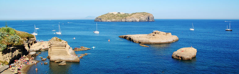
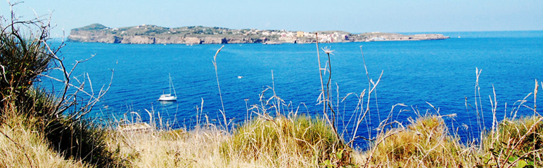
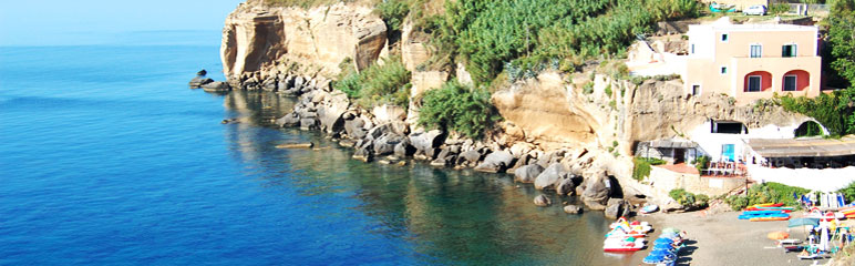
The beauty of this itinerary is strictly correlated to the origins of the island. Ventotene is in fact the creation of erupted lava from a sea volcano that exploded about a million and a half years ago and left it’s form on the seabed. It’s volcanic origins explain the characteristics of the island’s coastline, steep and craggy, polished by wind and sea with rare inlets. There are few beaches but many beautiful spots to be discovered by boat. Leaving Porto Romano towards the right you pass by Cala Nave and in front of the Fontanelle (‘little fountains’, the name due to the spurts of drinking water that gushed out after it rained), which has many lovely coves. It is not advisable however to explore them because of the friability of the tufa and thus the risk of a landslide. Continuing along the route for a few minutes one arrives to Cala Battaglia. The beach is quite large and protected, it can only be reached by sea because the land trail leading to it is has almost been completely destroyed by various landslides (it belonged to the Battaglia Family). Moving towards Capo dell ‘Arco one arrives to Parata della Postina, a small pebble and sand beach, protected by a long semi-submerged arch that provides respite for tanners during the hot summer.
Moving towards Capo dell’Arco, a rocky cliff 139 meters high, the geological characteristics of the land start to change from yellow tufa to black basalt. It is perhaps the most spectacular place on the island with it’s majestic coast line full of surprises such as natural swimming pools and deep blue waters. There are many resting places on the smooth rocks that jut out of it’s waters. At the southernmost tip of the island there is a beautiful inlet with a multicolored natural pool that it is about a meter deep. It is a great place for a swim and your snorkel and mask are a must or you’ll miss out on the incredible underwater show of Mediterranean flora and fauna.
Behind the splendor of Ventotene lies a tragic event that will remain in the memory of the island community. On the 24th of July 1943, a steamship names ‘Santa Lucia’ started its’ planned route from Ponza towards Gaeta. While it was cruising past Ventotene, at about two miles west of the island, the English air force opened fire on the ship. All but one of the passengers died; the captain miraculously survived the massacre. The wreckage lies 45 meters deep near Capo dell’Arco. Authorities and families congregate regularly at the place where the ship sank to remember those who were lost on that terrible day.
Continuing towards Porto Nuovo and passing through the narrow inlet of Parata Grande, there lies a small cove covered by a tufa ridge in the area of Punta Eolo. There is another black pebbled beach for the most part in the shade apart from on the large smooth rocks to the left (looking towards the sea), which are a perfect observation point of the Sconcigli. Scuba divers will enjoy exploring the bottom of the canal which, until the Sconcigli, is full of calcified fragments of antique vases as well as the remains of ship wrecks that would (and still do) sink to the rocky ocean floor.
Towards the right of the cove there are numerous semi-submerged passageways that offer exciting danger-free discoveries. Entering the largest cave, on the right one can hear echoes of the roaring sea that slithers in through a large opening towards the back of the cave. Blue and green reflections of the water on the walls make it seem like a salamander’s cavern. The passage used to be very close on the left and while it has become lower and darker it still is high enough to stand in and has enough light pouring in from the entrance.
Continuing on to the Pietre Tagliate, the coast line becomes deeply carved with regular square marks. In the area of the imperial villa, the Ventotene settlers carved out large blocks of tufa to use as building material for their homes and in the process they destroyed some archeological ruins but at the same time created ideal diving platforms for future generations.
Nature itinerary - Canoe Paddling

For those who do not have a canoe, they can be rented at the boatmen's co-operative, situated on the dock of Porto Romano. It is very important to verify wind and sea conditions before you embark, to wear a life jacket and to bring drinking water and a hat. It is advised to leave at dawn for those who want to take beautiful photos and have a good chance at seeing some dolphins. Bring a packed lunch, that way you can spend the whole day at sea, stopping in some of the wilder and more solitary coves that cannot be reached on foot. In the spring and the autumn there are numerous varieties of birds to see such as falcons, herons, plovers and even the odd kingfisher along the rocky coastline.
When choosing a place to rest among the coves it is advised to be prudent as some are perpendicular to the rock face and it is common for rocks to break off and fall.
LeavinLeaving Porto Romano go in the direction of the lighthouse, with the Peschiera Romana on your right. Follow the coast line weaving through the rocks of Nave di terra and Nave di Fuori and after a few minutes you will get to the Mast' Alfonso canal and Cala Nave beach. Going towards Punta di Arturo, just after the Fontanelle, there are caves that can only be explored by canoe within the tufa rock face. Moving on you will get to Cala Battaglia, a small beach situated under an impressive tufa wall. Cala Postina, a beautiful beach, is just after as is Spiaggia degli Innamorati (the lover’s beach) which can only be reached by sea.
The coast continues till Acqua Dolce point with a high wall full of wind-eroded stratifications in the yellow tufa stone. From this point the coast line is made up of layered basaltic rock, the result of several volcanic eruptions. The sea here change colors, becoming even more blue and emerald green. Even more beautiful, at sea level, are many small hidden caves where the water shines with the most spectacular colors. passing PunBefore passing Punta dell'Arco one can see the Saliere: holes in the rocks that served to collect salt. Punta dell'Arco, named this way because it has the shape of an arch, is the highest and most unique point of the island. It is made up of black rocks and crystal clear emerald natural pools. The arch presents a powerful image, both fascinating and baffling to the viewer.
Once you have passed the Punta, navigate west running along pebbled beaches called Moggio di Terra and Paratella till you reach Punta Grande. The sea level at this point lowers and the water weaves around the Sconcigle, two basaltic triangular rocks that serve as nests for sea gulls and puffins. In this part of the coast it feels as though one were ‘dentro anguste grottem’, in a pirates’ haven, which was in fact a constant danger for ships that passed by an uninhabited Ventotene during those perilous times. On the 10th of July 1771 King Ferdinand IV decreed that the island be repopulated so as to put a stop to pirate raids. The King provided land and economic support to 120 settlers, forbearers of todays inhabitants. rds the port you might, with a bit of luck and knowledge, pass the peak of Mamma Bianca and discover a beautiful tufa cave. The cave opens onto a small and charming beach near another cave. If you look up you will probably see nests of pelegrin falcons in the higher part of the rocky wall. The last stretch of our itinerary passes by Punta Eolo (where the ruins of villa Giulia are located) and moving close to the dam underneath Porto Nuovo, you will get to the cave of Queen Giovanna. In the cave there is a tufa pool where they say the Roman Queens would bathe. Keep going and you will enter Cala Rossano bay, where the tourist port is situated. Finally, paddle to the right of the intermural of Porto Nuovo and you will arrive at the point of departure: Porto Romano.
